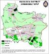
Green belt information
Approximately 63% of the Basildon Borough is countryside set within the Green Belt. It has a diverse character, ranging from the Thames-side marshes south of Basildon, to the wildlife areas of Langdon Hills and wooded and unspoilt lowlands of Billericay and Wickford.
What is Green Belt?
Green Belts have been established around major built-up areas in England, (such as London) since 1947.
They can shape patterns of urban development and help to ensure that development occurs in appropriate locations in accordance with development plans.
They help to protect the countryside, be it in agricultural, forestry or other uses and can assist in moving towards more sustainable patterns of urban development.
National planning policy, in the form of the National Planning Policy Framework (opens new window), sets out the five purposes of Green Belts which are:
- to check the unrestricted sprawl of large built up areas
- to prevent neighbouring towns from merging into one another
- to assist in safeguarding the countryside from encroachment
- to preserve the setting and special character of historic towns
- to assist in urban regeneration, by encouraging the recycling of derelict and other urban land
Basildon Council has adopted local planning policy to control development in the Green Belt, which is contained within the Local Plan.
Areas of Basildon Borough classified as Green Belt

See: Green belt map
PLEASE NOTE:
The Green Belt Map is not to scale and is for illustrative purposes only. Accurate designation of specific sites within the Green Belt MUST ONLY be taken from the Basildon Local Plan Proposals Map, which accompanies the adopted Planning Policy.
The number of people who live in the Green Belt in the Basildon Borough

Basildon Borough Green Belt Policy
The Basildon Local Plan has eight policies with regard to the Green Belt and the control of development within it.
BAS GB1 - The Definition of the Green Belt
BAS GB2 - Development in the Green Belt
BAS GB3 - Replacement Dwellings in the Green Belt
BAS GB4 - Extensions to Dwellings in the Green Belt
BAS GB5 - Definition of a Dwelling
BAS GB6 - Agricultural Workers Dwellings
BAS GB7 - Re-use of Buildings in the Green Belt
BAS GB8 - Plotland Areas
The above policies can be viewed in the Planning Policy
What Green Belt status means with regard to development
Certain uses or development are deemed to be inappropriate development within the Green Belt and may be refused planning permission upon application.
What Green Belt status means with regard to extending your home
Specific policies apply to the extension of dwellings in the Green Belt.
You may find that you are limited in terms of the size you can extend your property by and the way in which you can extend it, if that is, you are permitted to extend it at all.
Contact us if you feel that you need assistance in understanding the Green Belt extension policy or you need advice regarding a specific application or site.
Plotland Areas

The Plotlands originate from the arrival of the railways, which improved the accessibility of the Essex countryside to city dwellers from London.
Farmers and other landowners divided their fields into narrow plots, which many city dwellers bought and preceded to build small shacks and dwellings that they could visit at weekends and holidays to get away from the City.
Most of these properties did not have the benefits of running water, sewage disposal or electricity and were located down unmade tracks, sometimes miles from any services.
Thirteen of these communities remain, although they now have connections to electricity, water and gas/oil services and have a means of waste disposal.
They have a semi-rural character that is still typified privately maintained roads, varying dwelling plot sizes, natural property boundaries and vacant plots. The thirteen communities are:
- Fobbing (Moores Avenue/Hertford Drive/Woodlands Drive/Brook Drive)
- Bells Hill Road/Hawkesbury Bush Lane
- Stormont Way, Langdon Hills
- Northlands, Langdon Hills
- Green Lane, Little Burstead
- Broomhills Chase, Little Burstead
- Break Egg Hill, Billericay
- Crays Hill (settlement outside defined village boundary)
- New House Farm and Castledon Road, Wickford
- Ramsden View Road, Wickford
- Fairmead, Wickford
- Wickford Lawn, Shotgate
- North Benfleet
Development within the Plotlands is controlled with a combination of a specific Plotlands policy BAS GB8 and more generic Green Belt policies that are contained within the Planning Policy.
